
Text: Alan Bulmer Images: Paul Smith & Mark Hoffman
New Zealand has around 15,500 kilometres of coastline and as a consequence is blessed with lots of harbours and river mouths for anglers to explore. Most hold large numbers of fish and a surprising proportion of these may be trophy specimens.
Estuarine environments are often dominated by large expanses of sand or mud which are fully exposed at low tide. These sand flats are generally hold significant quantities of shellfish, crabs and marine worms and it is these organisms which sustain fish living in the estuary. Sprinkled across theses expanses are a network of smaller capillaries which drain into the main artery of the estuary. Fish use these capillaries as pathways to access the flats as the tide rises and to leave the flats as the tide begins to ebb. Consequently a good place to target is where the capillaries enter the estuary proper as this is where the big fish lie in wait.
So how do you go about finding a flat to stalk?
My preferred method is to use Google Earth to identify potential spots in harbours and then follow this up by consulting a marine chart, if one exists for the target area. I’m looking for deep holes that are close to shallow flats that will be exposed at low tide. The reason for this is that snapper will hold in the holes at low tide and move onto the flats with the flood tide to feed. Kahawai, kingfish and trevally will generally make their way into the deeper holes as the tide starts to drop and wait for the fish that have been feeding on the flats to move off them as the tide ebbs. If you want to learn more about the features which attract fish to certain areas then click on:- https://activeanglingnz.com/2015/09/10/habitats-where-fish-are-found/

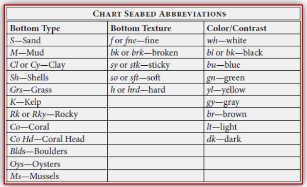
In the chart image above you’ll see that the hole formed off Shag Point is slightly downstream of where two channels meet. Channel confluences often scour out holes and they are great places to look for. Note also that the flat near Shag Point has an M written on it. This means that the sea floor is Mud so while the spot looks promising it may not be accessible at low tide. Look for flats where the seabed is S (Sand) or Sh. (Shells). Hard packed sand or broken shell is best.
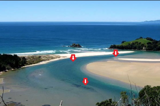
The image below is of another harbour. I checked it out on Google Earth and then fished it. The arrows show where I had success. The lower arrow points to a deep area near a patch of foul, the second a confluence of two channels and the arrow furthest right pinpoints a deep gut close to the harbour mouth near a small side channel. All are areas where fish are concentrated for brief periods on the outgoing tide.
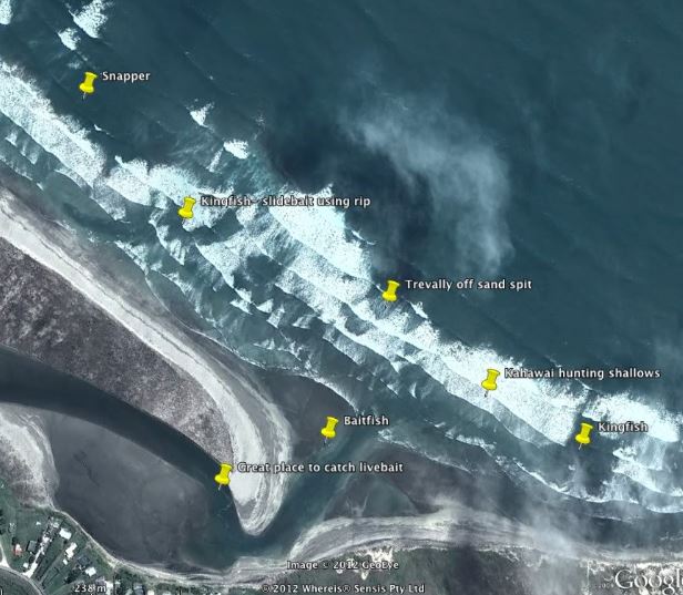
The Google Earth image below is of another harbour entrance. The pins show where various fish species will be found, depending on the state of the tide and where the rips and eddies are forming. Search for the channels on Google Earth and target them.
Remember that most sand flats can often only be accessed within a couple of hours either side of low tide. Anglers must use this window of opportunity to cross the sand to fish in the main channels of the estuary as this is where the fish are concentrated as water levels recede.
There is nowhere for an angler to hide on a featureless sand flat. No shade in the heat of summer and no shelter from the wind or rain during the winter. Flats are a brutal place where it is not uncommon for the weather to change completely within half an hour and for the unwary to be drenched by a passing rain squall. Anglers who fish the flats must be prepared for these eventualities and dress accordingly. A back pack containing extra clothing layers and waterproof garments is virtually a necessity.
It is important to take care and try to stalk fish when exploring the flats. However, the lack of cover makes it difficult for an angler stalking fish to remain inconspicuous. To counter this it is a smart move to wear either camouflage clothing or drab hues which match the surrounding back drops. Flats anglers are effectively hunting with a rod and must try not to do anything untoward which will alert fish to their presence.
Move very slowly as you approach the main channels, carefully scanning the margins through Polaroid sunglasses for fish and signs of activity. Often the best chance of success is with the first few casts so every care must be taken not to disturb fish sitting close to the shore or those feeding on bait fish which they have driven into the shallows. Fish the shallows thoroughly and try not enter the water. Just like in a river, entering the water drives fish further away from the angler.
Fish tend to drop back towards the estuary mouth as the tide recedes. They do this in stages and tend to pause in holes, behind obstructions or beneath vessels to lie in wait for smaller fish following a similar path. Finding these temporary holding lies can sometimes mean the difference between success and failure.
Move downstream with the ebbing tide exploring the main channel systematically. Spend extra time prospecting where capillaries drain the sand flat. Try not to make too much noise and proceed slowly and stealthily. Over summer, moving slowly can be important as the heat can be oppressive. Keep your eyes open and freeze whenever you see something untoward.

Learn how to cast accurately as you may only get one chance to present your fly or lure in front of a feeding fish. In flats fishing you need to learn how to read the water and take advantage of every opportunity that presents itself, irrespective of how fleeting it may be. My preference is to fish at dawn or dusk as this is when the fish are often most active. Be careful if you fish at dusk not to get marooned on the flat by the incoming tide.
One thing that is a magnet for bigger fish is current. Look for rips or spots where the current quickens. The big fish will be waiting nearby to attack bait fish that are disoriented by the increased flow and unable to easily take evasive action.
For more information on stalking the flats check out the following AANZ links:-
- Lures – https://activeanglingnz.com/2014/05/05/stalking-the-flats-part-4/
- Flies – https://activeanglingnz.com/2016/04/12/fly-patterns-for-the-flats/
- Fishing soft plastics – https://activeanglingnz.com/2015/07/25/wetlining-soft-plastics/
- Stalking the flats presentation:- https://activeanglingnz.com/2015/10/15/video-stalking-the-flats-presentation/
- Spinning tackle:- https://activeanglingnz.com/2014/04/27/stalking-the-flats-part-3/
- Clothing:- https://activeanglingnz.com/2016/03/21/does-camoflage-clothing-work/
- What to look for:- https://activeanglingnz.com/2014/04/21/stalking-the-flats-part-2-what-to-look-for/
Hopefully the above note has inspired you get out there and have a crack on your local estuary. Search Google Earth for the right places to focus on and get out there. You’ll be surprised at what you find!

One thought on “HOW TO FIND AND STALK THE FLATS”